Welcome to the LnLP Forums and Resource Area

We have updated our forums to the latest version. If you had an account you should be able to log in and use it as before. If not please create an account and we look forward to having you as a member.

Gold Juno Sword map progress

Grognerd

Member
Joined
Nov 28, 2017
Messages
215
Points
28
Age
72
Location
Melbourne, USA
Well it is certainly a tedious job making a map - but the editor is pretty easy to use.
Still need to finish 40, 30, 20 and 10 meter topography on the left of the Ourne River. Then the road network, rail network, the trees, orchards and all. Not to mention Cities, towns.
Then I'll see how hard the Establishment Editor and Scenario Editor are to use.

BIE, may I use your Sword establishments to build off of? Would save some time.unfinished GJS.jpg
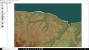
I think are source maps are pretty much the same = US War Office updated 1943 1:1000000 scale.
 

Bie

Member
Joined
Feb 22, 2017
Messages
350
Points
28
Age
42
Location
Belgium
That sure looks very promising!
Sure Grognerd you can my estab.
 

rocketman

Member
Joined
Jan 6, 2016
Messages
100
Points
18
Age
53
Location
Sweden
@Grognerd I have completely missed this one. I started work on a Juno-Caen map a long time ago but lost energy to complete it. It was supposed to be a D-day to D+7 scenario. I used 10 m elevation intervals - what do you use. If you think it will be of any help I would be happy to send it to you.
 

Grognerd

Member
Joined
Nov 28, 2017
Messages
215
Points
28
Age
72
Location
Melbourne, USA
@Grognerd I have completely missed this one. I started work on a Juno-Caen map a long time ago but lost energy to complete it. It was supposed to be a D-day to D+7 scenario. I used 10 m elevation intervals - what do you use. If you think it will be of any help I would be happy to send it to you.

I lose the energy to finish stuff all the time - Don't feel alone there - HA! I was finishing this up and got a hankering to work back on the Guadalcanal map for a bit, ran out of elevations at Mt. Austen, so I have to rework elevations a little. Now I'm back working on this one. My source map (MapScan0) is 10 meters per hex.
 
Top