Grognerd
Member
Wow, you know I'm not sure why I keep calling you Jim, since I know your John. Old person syndrome I guess. I'm glad you have a good sense of humor. I'm slightly embarrassed (but I'll get over it! HA!) My apologies.
I'd better get on the ballWell, it's true that Jim is always there, Grognerd - like what? - like our 'fairy quartermaster', perhaps...but actually in this case I beat him to it. The relevant sub-folder to swap out the files in, is the Map folder in the graphics folder, by the way.
") !
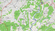
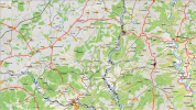
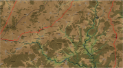
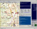
!I've always had trouble differentiating land cover colors from the solid land contour colors used in CO2.Hello, I'm new on this forum, "young french military retired" after 37 years and fan of CO2 since the original version "CO battle of bulge". However I did'nt have enough time to play the game since I left the army 2 years ago. Discovering the forum and particularly this topic, I agree with the interest of topo map. Then I tried to change with Mapmaker the look of an original map in a topographical one (2 views attached and the original one ref= map ST avid) . Since there I've been playing with my version (no bug for the moment). I'm open to any remarks and suggestions. Sorry for my poor english.
I already created a full scenario including map, estab .... for myself . It's a "modern warfare" one between a western blue force and a red OPFOR (brigade/battalion/ coy level) . Even if it's fun, it lacks main parameters like helicopters and others. Even for airstrikes, I' not entirely satisfied as parameters can't be changed (except numbers) If anybody has suggestions to improve....Looks pretty good to me, now comes the fun part - creating all the other parts to create a full scenario.
you're right : I created a complete map in the north of France (60km x 60km), using variations of 30 meters per variation (maxi authorized!).I've always had trouble differentiating land cover colors from the solid land contour colors used in CO2.
So, I find the contour lines for height offering a more intuitive feel for the height differences. Fully agree
However, CO2 limits the number of contours to 15 steps for all the height variations on the map in mountainous terrain, these generally track standard topographical maps, however on plains (such as the North Africa desert or Belgian Heide scenarios) the CO2 standard allows for subtle variations (2-meters per contour for example) in land contour to serve as tactical defensive or offensive dispositions (armor hull down for instance).
I'm not strong enough in computer data to answer to this. The answer is in "Dave's hands". My opinion is it should be only possible if you create a new game. I only use Map maker tool (ie I use "dig lines" and modifie colour, parameters... in order to draw contour lines)Is there a possibility of mixing and matching contour lines patterns with "standard" intervals (solid line for example) found on topographical maps and CO2 "game" (some form of dotted line for example) intervals?
I dream of a wargame able to include directly maps from geographical software like QGIS.It's probably not a game breaker in conversion but would allow for easier conversion of standard topographical maps into combat maps.
you're right : I created a complete map in the north of France (60km x 60km), using variations of 30 meters per variation (maxi authorized!).
In fact it depends the scale of the map linked with the scale of units. The main purpose of CO2, if I'm right is the chain of command (I don't find as efficient in other wargames). The commander of a military force (N level) orders to (N-1 ) level and some specific units under direct command . Then to well coordinate all the N-1 level units he needs to know/follow their immediate sub-units (N-2) level : ie a brigade commander orders to Battalion level and specific units sized coy/platoon (RECE, infiltrated units, specific support assets) and needs to know/follow the Coy level (units lines) but ART batteries too to know the areas covered by fire) and of course the specific assets under direct brigade direct command.
Today with computer tools, many wargames mix tactical levels (Battalion /coy /platoon /section) with higher ones (army/division/brigades) in the same play. I think it's a mistake in view of the engagement standards of each level and their specific maneuvers. In my opinion the "tactical frontier" for wargame is Battalion level.
So if we want to play maxi a Battalion commander (that means you need to give orders to Coy/platoon/sections) then we need low map scale (2p/meters 1/125000, see lower?), more precised urban area..... including precised height variations
If the aim of the game is Brigade commander or higher (division army), 1/50 000 maps (16p/meters in CO2) are precised enough to give orders/follow icons level coys and other specific units..... 10m between contour should be sufficient as included in 1/50000 topo maps
Coming back to CO2 , my opinion is that the game is very well fitted for Brigade level (or higher). Maybe I'm wrong. Regarding what I developed above, I only use the more precise map scale (ie 2p/meters 1/12500) to be sure that the Coy will be well positioned to see/fire/Hide/selfprotect. (A well-trained one does it itself) and for airstrikes. Some players developed "platoon scenarios" with CO battle of the bulge. I was not convinced.
I'm not strong enough in computer data to answer to this. The answer is in "Dave's hands". My opinion is it should be only possible if you create a new game. I only use Map maker tool (ie I use "dig lines" and modifie colour, parameters... in order to draw contour lines)
I dream of a wargame able to include directly maps from geographical software like QGIS.
Apologize for the length of the text.
Many thanks for your answer. I'd perfectly understood the chain of command parameters but your outstanding post completes my knowledge of the game and will greatly help the "novice player" in the future.Hopefully this isn't redundant with your understanding, but it may help to understand the mechanics of the game.
1. In its broadest terms, the game is designed to be played within the command and control span of the highest level of command on the map (termed "the on map boss"). The span is measured in how many subordinate-formations the "on map boss" can control effectively with the staffing at the command echelon. A division command may have a span of 10, meaning the command staff can directly order 10 subordinate organizations within its chain of command before incurring penalties in responsiveness and time to initiate the ordered mission.
The subordinate units which count are measured from the next lower echelon of command down to the game's standard company level formation.
So, if the division commander orders a brigade to perform a mission, the command staff span of control is burdened with 1 subordinate. It can issue nine more orders without incurring command and control penalties.
If that same division commander chose to individually order 10 separate companies to perform diverse missions before ordering the brigade into action, the response for the brigade will be delayed significantly because the command span was exceeded.
There are other penalties involved dealing with time delays in sending orders through the echelons of command and distance over which the order is transmitted, but in broadest terms the constraining mechanic is the command span for the "on map boss."
2. The game is designed to a couple of standard measurements, area and distance measures and terrain effects are based on 100 meter increments -- the terrain effects other than rivers and routes being the most frequently found terrain feature in a 100 x 100 meter grid (a grid with 60-percent wooded land and 40-percent grass land would be considered a wooded location for sighting and force protection purposes).
This is done for a couple of reasons.
a. The company is the lowest level standard formation on the map. A company is assumed to have a 100-meter facing and direct influence over a 100 x 100 - meter grid when deployed. Something like independent scout platoons, mortar platoons and gun squads / batteries are considered "companies" for game play purposes.
b. Sighting and visibility effects are calculated at 100-meter increments to avoid excessive time delays in altering the dynamic sighting and visibility effects for all the units on the map.
There have been some efforts to design a game for lower tactical levels of command, using platoons as standard unit size and reducing the grid for measurements to smaller than 100-meter increments, but the game seems to bog down as the more refined measurements necessary to make a platoon effective are calculated.
3. Height measurements for terrain affecting visibility and protection are calculated as the standard height of an individual soldier -- roughly 2-meters. Brush anticipated to be 2-meters in height will interfere with a soldier's visibility into an area affecting intel and fire accuracy. Grasslands designed to be no more than 1-meter in height would not interfere with visibility.
These measurements affect the tactics a force can use and intelligence a force can gather on the map.
Most scenarios are designed around the operational level (corps and above), but tend to play best when commanded at the battalion level. Some of this depends on the map size and how many different chains of command report to an "on map boss."
I don't have access to it at the moment (suffered a computer crash and lost the software), but there was a routine written by Ioncore to begin conversion of standard OGIS information into battle maps.
Right now we're waiting for an update dealing in more intuitive and effective artificial intelligence response from formations when ordered to attack, so the mapmaking improvements remain on the back burner using non-standard (Alpha / Beta) software.
I'm not aware of any scenarios designed as you describe.Many thanks for your answer. I'd perfectly understood the chain of command parameters but your outstanding post completes my knowledge of the game and will greatly help the "novice player" in the future.
Now it's clear for me that the company is the lowest level standard formation on the map (Even you can create create lower units with the estab software). Playing several operational scenarios of the game, I effectively noted they are better played at Battalion level despite the level of the"on map boss" (Army or division one). It's why I wrote in my precedent post that "CO2 seems to be well fitted to Brigade level" because of the need in many cases to "help" the IA to "manage" sub-units, specially coy ones.
One question: do you know if a scenario with Division/ Brigades/Line Battalion icons ( Battalions as the lowest level deployed and if the Icon regroup the whole strength of the battalion) is playable? I guess no because of what you explained to me about visibility, height....
I'm going to look for the routine mentioned in your post
Best regards
Indeed Sir!Yep, Jim has a pretty deep understanding of the game, bravo!
These scenarios are hypothetical. I'was just wondering about it. If I well understood what you explain about parameters in a outstanding way , I gess the game was designed to imperatively deal with coys as the lowest level, so that the play remains realistic.I'm not aware of any scenarios designed as you describe.
It's possible if one wanted to take the time to aggregate personnel quantities, equipment and weapons allocations normally assigned to companies and squads up to an all inclusive battalion structure.
There's a limiting factor of 2,000 square kilometers (40 x 50 KM) on the map size. That could cause complications on playability if the lowest command structure were battalions. Also, if the map grid is adjusted to the battalion footprint (I'd guess 400 x 400 meters), it would make the map terrain effects even more abstract than a percentage of a 100 x 100-meter grid.
If you're looking particularly at the terrain in France, Bie posted several scenarios with maps of the terrain around Caen and there are a couple of user-made scenarios with maps of the Normandy beaches where US troops landed.These scenarios are hypothetical. I'was just wondering about it. If I well understood what you explain about parameters in a outstanding way , I gess the game was designed to imperatively deal with coys as the lowest level, so that the play remains realistic.
I began to read the routine written by Ioncore... about QGIS (thanks once again)
Best regards
Hm... Say one of your coys has taken position in the woods (camouflaged and protected by trees and foxholes) and an enemy coy on patrol enters the grass land part, then your coy should have full view on the enemy, while the enemy walks by in the open, maybe even without being able to spot your ambush party. The game should hand out a hefty penalty to the enemy unit regarding sighting and set the protection to 0, while your unit should receive various bonuses (sighting, protection, etc.), and only receive hefty penalties if it receives HE/airburst fire, no?(a grid with 60-percent wooded land and 40-percent grass land would be considered a wooded location for sighting and force protection purposes).
The friendly AI used to set up/perform beautiful plans/moves on the regimental level, which - back in the day (HTTR/COTA) - made MarkShot tend to say that the AI performed best when the player issued orders to regimental HQs, instead of divisional or Bn HQs. I used to second that. With all the changes, it may be somewhat different now, but even in CO1 you could see say a Rgt. HQ sending out a Bn as flanking force (often with brilliantly executed wide marches bypassing the enemy main force/defensive line), while the main force, the remaining Bns, would directly approach the enemy. Such moves looked as if they were made for military academy playbooks.... just beautiful.Most scenarios are designed around the operational level (corps and above), but tend to play best when commanded at the battalion level. Some of this depends on the map size and how many different chains of command report to an "on map boss."
I'd agree there. Besides the map limits and the possible negative effects on playability, coys are needed to represent/accurately depict the tactical level. You can't just shuffle around "Bn bodies" and not consider flanking manoeuvres, forces trying to hold/stop advancing foes or cutting off enemy supply lines. In reality, such missions are transfered to and performed by the Bns, which then shuffle their coys around, accordingly. In reality, a full Bn would not defend a tiny village, for instance. The Bn HQ would task a single Coy with the defense and then order its coys to rotate say every 24 hrs.There's a limiting factor of 2,000 square kilometers (40 x 50 KM) on the map size. That could cause complications on playability if the lowest command structure were battalions. Also, if the map grid is adjusted to the battalion footprint (I'd guess 400 x 400 meters), it would make the map terrain effects even more abstract than a percentage of a 100 x 100-meter grid.
I tend to think that it should be "easy" to have the map maker (or the game engine on map load?) add an outline (ie. a dark green solid or dottet line) to each terrain layer, automatically. The map would then a) keep the colorful appearance, which is the iconic visual/feature in CO2, but it would b) also receive a look that would resemble contour lines in topo maps. You still won't receive the actual accuracy of highres topo maps, but the readability of the terrain would go way up, imho. Just an idea.Is there a possibility of mixing and matching contour lines patterns with "standard" intervals (solid line for example) found on topographical maps and CO2 "game" (some form of dotted line for example) intervals?
Hm... Say one of your coys has taken position in the woods (camouflaged and protected by trees and foxholes) and an enemy coy on patrol enters the grass land part, then your coy should have full view on the enemy, while the enemy walks by in the open, maybe even without being able to spot your ambush party. The game should hand out a hefty penalty to the enemy unit regarding sighting and set the protection to 0, while your unit should receive various bonuses (sighting, protection, etc.), and only receive hefty penalties if it receives HE/airburst fire, no?
The friendly AI used to set up/perform beautiful plans/moves on the regimental level, which - back in the day (HTTR/COTA) - made MarkShot tend to say that the AI performed best when the player issued orders to regimental HQs, instead of divisional or Bn HQs. I used to second that. With all the changes, it may be somewhat different now, but even in CO1 you could see say a Rgt. HQ sending out a Bn as flanking force (often with brilliantly executed wide marches bypassing the enemy main force/defensive line), while the main force, the remaining Bns, would directly approach the enemy. Such moves looked as if they were made for military academy playbooks.... just beautiful.
In turn, attack orders issued to Bn HQs turned out to be really frustrating at times, which dealt with the routing policy of single coys, where 1 routing/retreating friendly coy pretty much compromised the entire operation (say with 3 coys and 1 heavy weapons unit involved, maybe even + 1 small tank element). I suggested to review the routing regime, a while ago, I think it would actually enhance the gameplay experience quite a bit, especially if playing below the regimental level.