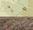
One thing you can immediately see is that the ridge around Lophi in game is all one contour on the map (due to the 100m contours), while the actual contour from Google Earth is very complex. Without being able to see the 3D contours with their own eyes, it's impossible to determine where the ridge line is. The only way is to use one of the 4 methods listed above.
The highest elevation in the area is the top of a mountain range (way west of Lofoi, ~ 1,089 meters), the nearest top has a height of 822 meters. None of the major ridges are represented in that map.
View from the southwest, the 2 ridges (the village resides in a depression between them) offer a visual range of 15-16 km, where only the mountains in the background limit that visibility.:
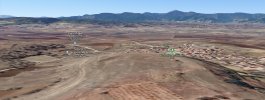
What program/website did you use to display the Lofoi area? The hill (blue arrow) in your screenshot is not present in google earth, but your screen has more distinct/detailed depressions (especially the little ravine just right of Lofoi):
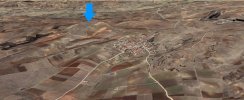
View from the West, no hill in Google Earth (note: Earth uses more sources than Google maps):
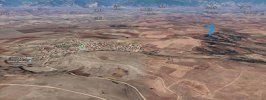
The highest elevations in the immediate area (red: rough visualization of the ridge lines):
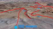
The Lofoi area is not accurately rendered in the game, instead of being packed between 2 major ridges, only the northern outskirts are on a slope, the depression/valley that spans through the center of Lofoi is not fully rendered.
Inaccuracies aside, I think a timed/future outlook would reduce the realism. The LoS tool already gives you the opportunity to check the visual ranges from any spot on the map, even if you have not positioned any of your units at the LoS start point.
This is already a very powerful tool/ability, which commanders did not have, at the time.
In reality, say if a divisional commander wanted to place a recon/early warning element on an elevated piece of land, then he needed detailed contour maps, if he wanted to pick the position himself. More than often, there were no accurate/detailed contour maps available, so the units had to actually go there and recon/assess or even draw the terrain layout, which they then reported/showed to the superior CO, who then formed a decision. In some situations combat units got in bad situations, as they encountered terrain features that were not outlined in any of their maps.
Like hills weren't indicated on some maps, unpaved roads indicated on maps had "disappeared", as they were either just tracks or abandoned + overgrown unpaved roads. Other roads were converted to farmland or to railroad embankments.
Quite a few US coys were issued copies of hastily produced maps (some even looked like maps that were hand-drawn from memory) with a number of major woods indicated but with 0 contour lines, when they entered Germany.
For instance, US and British intel/GSGS staff often relied on German road maps from the 1930s, which were sold at German gas stations or issued to members of automobile associations, for Allied bomber missions over Germany or for the thrust to Germany in 1944.
An almost unaltered commercial road map from 1935 that was used by Allied air units in 1943, 2 highways (1 was suspected to still be under construction) were added along with a number of other details, some roads and parts of the railroad network were superimposed with data from 1939 to gain a more recent/realistic map:
The map legend indicates that
- topographical maps (of German origin) were then superimposed to display some rough contour lines,
- the topography information derived from a German map collection (atlas) that displayed Germany and its borders from 1914 - 1926, and from a map from 1934
- the road network layout was taken from 2 official road maps (1937 + 1939), the highway layout from an official public highway map (1939) and the railway network info gathered from a public railway map (1939),
- additional general infos includ. more "recent" topogr. infos were taken from a map from 1934,
- and that other infos (say about power supply lines and other vital infrastructure) were based on intelligence reports from 1942:
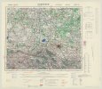
When they were lucky, they could rely on "Messtischblätter" (translates to "measureing table sheets" or "plane table sheets"), means artillery grids.
Problem:
While they were the most detailed maps regarding the street and building layouts, most of them were even older than the available road maps, they did not contain very detailed contour lines (if any) and were rarely available to the GSGS.
The following map is an original/official German artillery grid of the Hemelingen area (suburb of the city of Bremen) from
1925, the only
detailed map of the area the British could muster:
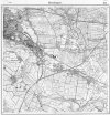
Since recent versions of the grids covering Germany were secret documents kept in German archives, recent maps could not be obtained in 1943, ofc., so the Brits issued an edited version of the Hemelingen grid from 1925, in 1944. The edits could only be made when more aerial recon photographs became available in late 1943 and the following months. When clouds or weather conditions obscured parts of the view, particular obscured terrain features, bunker installations, buildings etc. would be missing, ofc., means not all areas could be updated. The Germans also used smoke generators to obscure harbors or other areas of interest, too (Hemelingen had a port, for instance, the port offered access to the North Sea).
The revised map from 1944 (it was just re-issued in 1951, most likely for British occupation forces, hence the new time stamp):
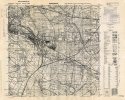
2 major factories in the southwest "disappeared" (maybe closed/demolished after the economic crisis - 1929), a highway appeared, some minor roads and a number of town houses were added, but many of the 1925 buildings are missing in this edit, even though it would have been more likely that some residential areas expanded, but the GSGS map insists that they shrunk, so I'm not sure if these parts are accurate. I wouldn't rule out that parts of the population had moved to the city during the Great depression and left these partially rural areas.
In contrast, a number of Italian GSGS maps were very sophisticated, as terrain features had been effortfully plotted (Sicily, Cassible area):
The few Allied maps that featured detailed contour lines on maps of Germany were often based on maps issued by the Land Statistical Offices (regional state agencies)
before 1914, which were either confiscated by Allied occupational forces (eg. the French in the Rhineland), handed over to Allied authorities after the armistice in 1918 or even obtained from various sources in the 1900s. Others were based on official contour maps from the 1920s.
So the contours on most of those maps were very accurate, but the layout of the road networks + infrastructure could be very flawed (as some of these infos were based on material that was as old as 18 yrs or even older).
This made Allied map production in 1943/1944 quite difficult.
EDIT: The Germans experienced a similar problem in 1940 and 1941, during the creation of the Barbarossa plans, btw. There were many "dark spots" on German military maps covering the Russian theater, vital infos were missing, major roads on maps turned out to be unpaved dirt roads, double-track railway lines turned out to be projected upgrades only and still being single-track lines, etc.
So, I tend to think the map creaters of the COTA maps relied a bit too much on military/historic maps at times (which could contain a lot of errors) instead of focusing a bit more on modern topographical data.
Usually, hills and ridges don't diseappear after/within 79 years, maybe except for some terrain modifications that come with some large-scale projects (eg. highway routes/bridges, development of large residential areas = satellite towns, etc.) .
There are very few exceptions where modifications came close to terraforming, eg. the removal of a number of hills within the city limits in Qingdao, China, where the hills had been completely removed to make room for additional residential areas.
