OK. What I was referring to was reading about flooding east of Amsterdam. Groningen was farther north and slightly west.
I'll be interested to see how your scenario turns out. High fidelity urban combat appears difficult to model with the 100-meter terrain map and the larger standard unit sizes in the Estabs.
You might review some of the discussion on Pegasus Bridge where Bie used a 25-meter grid and smaller units to replicate that battle.
Ah, I see what you mean.
Yes that's true about the high fidelity urban combat, however it's still going to be a relatively big map. I am experimenting with the middle option, not 100, not 25. But 50 instead. See how that goes. Will turn it up if neccesary.
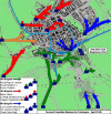
The general idea is to include the whole map, as the Canadians pushed north via Drenthe to reach Groningen. Generally I am planning to stay Semi-Accurate and make it a solely Canadian affair but might include a small Polish segment too, since Polish troops liberated almost everything east of the city of Groningen deep inside the province. However, the Germans will be far less accurate in what I have planned. I will considerably strengthen the defence to make it more fun for that side, since in reality the fact it took several days to take the city of Groningen was more due the fact that the city being very easy to defend than due to the strength of German forces. Morale was low, no cohesion, and only small parts of some SS divisions, Luftwaffe and Wehrmacht were present. Mindset was on survival and retreat. If I would be dead on accurate, the scenario would be almost completely in favour of the Canadians.
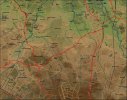
The first part of the map I was working on I have finished (see screenshot below, it is 19000 x 15000 meters). That's a bit more than half of what I planned to do. The one I am currently doing (predominantly province of Groningen) will merge/integrate on top of it, since it has the biggest city in the area and the main target for the Allies at the time (is 19000 x 13000). Both combined will mean 19000 width and 28000 height. Which is more or less the size of the Nijmegen map alone.
Here is the finished version of the first part of the map:

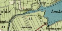
As is evident, this part is not so flat as one would expect from most of the Netherlands. Southern part is more "hilly" in comparison to the north. The scale is 1 til 15 meters. Highest point on the map is I believe 14 meters. The map I am planting on top will be a lot flatter, it is in fact mostly below sea level. The city itself is almost completely under sea level too. But as it is not possible (and not very relevant I think) to put something under sea level, it will stay at 0.
For anyone interested in the historic battle of Groningen:
https://www.canadiansoldiers.com/history/battlehonours/northwesteurope/groningen.htm


