Welcome to the LnLP Forums and Resource Area

We have updated our forums to the latest version. If you had an account you should be able to log in and use it as before. If not please create an account and we look forward to having you as a member.

Battle for Caen scenario - XXX Corps' Right Pincer

john connor

Member
Joined
Oct 22, 2014
Messages
2,488
Points
63
Age
60
Location
Brussels
I did some messing around. Maybe the problem isn't the bocage or the hedges. Have you got minor roads set to 3% for motorised? And tracks set to 40%? Check that first maybe. Maybe there's just an error in the minor roads settings. I'll check myself.
 

john connor

Member
Joined
Oct 22, 2014
Messages
2,488
Points
63
Age
60
Location
Brussels
UPDATE: Yes, I just checked. You've got minor roads set to 3% for motorised. So don't change anything else, lol - just change that first. Maybe that's all that I was noticing!! The setting should be somewhere between tracks and roads, clearly, and not 3%.
 

john connor

Member
Joined
Oct 22, 2014
Messages
2,488
Points
63
Age
60
Location
Brussels
Sorry, Bie. That does fix it. I set minor roads to 50% and it looks now like the presence or not of overlapping layers (whether hedge or bocage) doesn't afect it. My mistake as to what was going on. So that was the only change needed - to correct the minor roads settiong error. Cheers.
 

Bie

Member
Joined
Feb 22, 2017
Messages
350
Points
28
Age
42
Location
Belgium
Sorry, Bie. That does fix it. I set minor roads to 50% and it looks now like the presence or not of overlapping layers (whether hedge or bocage) doesn't afect it. My mistake as to what was going on. So that was the only change needed - to correct the minor roads settiong error. Cheers.
Ok that is very weird. I notice that when I create a new map the minor road defaults to 3% for motorized. When I load up a map from any of the modules this is set between 50% and 70%. This means that my Pegasus Bridge scenarios also have this problem, as I also started from scratch with them.

I'll definitely have to change this in all cases.
 

Bie

Member
Joined
Feb 22, 2017
Messages
350
Points
28
Age
42
Location
Belgium
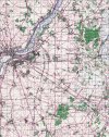
On to some more mapmaking. I miraculously managed to make a part of my Caen-Ouistreham map fit the a 1:100.000 GSGS map I cropped of the area southeast of Caen. So building on top of my earlier work I only need to create 144 km² of new map :)

For those interested, this is the map I'm going to use as mapscan:

Caen (Goodwood).jpg
 

Bie

Member
Joined
Feb 22, 2017
Messages
350
Points
28
Age
42
Location
Belgium
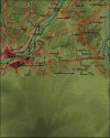
Quickly filled in the height map. Looks good if I say so myself.

Goodwood Relief.jpg
 

Bie

Member
Joined
Feb 22, 2017
Messages
350
Points
28
Age
42
Location
Belgium
Looking great. Goodwood. Very exciting. You already have the estabs you need?

Haven't really checked the OOB's yet but I imagine I'll be using the estabs I've been using from my other scenarios. I'll just add the stuff I need when it presents itself.
 
Last edited:
Top