Thanks for the feedback guys, I really appreciate it, as it helps to decide on the next step forward, and gives me a chance to explain why things have been done the way they have.
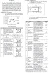
In my opinion this game is more an operational simulator than a game, so I have decided to use the correct symbol terminology as is depicted in FM 1-02 Operational Terms and Graphics, distributed for public release in 2004, by the Headquarters Department of the Army, for my maps.
At least as correct as the uniqueness of this situation allows and my limited knowledge of it permits.
The publication can be found here for download:
army.rotc.umich.edu/public/resources/FM1-02OperationalTerms.pdf
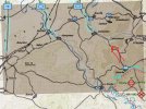
The arrows that I used in the Greyhound Dash map to indicate the Allied units entering from the north of the map, are the ones that indicate units in convoy.
This is because the Allied units in this scenario are racing their reserves through friendly territory to occupy key locations, especially those with bridges, in order to contain the breakthrough of the Axis armoured spearhead.
The Axis formations have just encountered some Allied rear echelon units, on their advance through enemy held territory, and have an axis of advance due north at this time.
It is entirely up to the player to decide the axis of advance from this point on.
The unit information is outside the symbol as Dave has already mentioned because that is the correct method as is detailed below:


